***********************************************************
The Hong Kong Observatory has developed the world's first LIDAR Windshear Alerting System (LIWAS). The system has been operating at the Hong Kong International Airport since the end of last year (2005), continuously scanning the runway flight paths and providing minute-to-minute warnings to aircraft landing and taking-off at the Airport.
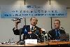
Mr Wai Hon-gor, Assistant Director of the Hong Kong Observatory and Captain Brian Greeves of the International Federation of Air Line Pilots' Associations (IFALPA), jointly briefed the media on the system at a press conference today (February 20).
He said, "The LIDAR Windshear Alerting System represents the result of years of scientific studies by the observatory and the concerted effort with users. It is the world's first operational system applying laser technology in airport windshear detection. The observatory is one of the world's leading pioneers in the application of remote sensing technology to windshear alerting at airports."
Captain Brian Greeves of the International Federation of Airline Pilots' Associations (IFALPA) said, "The development of the windshear detection technique by the HKO is world-beating technology and places Hong Kong as a centre of excellence within the aviation meteorological community."
The development of windshear technology at the HKO, including the use of LIDAR, has been published in the Bulletin of the World Meteorological Organization (WMO) - the official journal of the United Nations specialised agency. The Bulletin said that the warning of low-level windshear at the Hong Kong International Airport was delivered "using a combination of science, high-end technologies and user education".
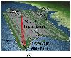
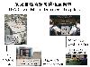
A LIDAR measures the wind by transmitting infrared light pulses and receiving the reflected light from dust particles in the air. The LIDAR Windshear Alerting System scans the landing and take-off flight paths (photo 1) with a laser beam to measure the winds ahead of the aircraft. The system continuously parses the wind data. When it detects windshear signatures, it provides alerts immediately for radio transmission to pilots (photo 2).
Ends/Monday, February 20, 2006
Issued at HKT 16:40
NNNN