***********************************************************
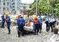
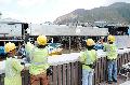
Relevant government departments and organisations conducted a rescue drill today (May 15) to enhance their preparedness in the event of serious flooding in Tai O, and to promote residents' understanding of the emergency response arrangements.
The Islands District Office, the Fire Services Department (FSD), the Police, the Hong Kong Observatory (HKO), the Drainage Services Department (DSD), the Social Welfare Department, the Housing Department, the Civil Aid Service (CAS), the Tai O Rural Committee, the Neighbourhood Advice-Action Council and the Hong Kong Young Women's Christian Association Tai O Community Work Office took part in the rescue drill.
The drill aimed to allow representatives from government departments and district organisations to familiarise themselves with the response plan, so that they will be able to act swiftly to evacuate residents and minimise the impact caused by flooding when the HKO issues an early alert.
The HKO will issue an early alert to relevant government departments/parties and village representatives/fishermen representatives by SMS when it forecasts that the sea level at Tai O would rise by 3.3 metres above Chart Datum (mCD) or more in the coming few hours during a tropical cyclone.
Upon receipt of the early alert, relevant departments will mobilise their resources for a possible evacuation and rescue and relief efforts while village representatives/fishermen representatives will help disseminate the information to residents so that they can be well prepared for the flood and take refuge in safe locations.
When the actual seawater level in Tai O reaches 3.0 mCD, the DSD will issue an alert to the relevant government departments/parties and village representatives/fishermen representatives concerned. The Police, the FSD, the CAS, social workers and village representatives/fishermen representatives will then urge residents in the low-lying areas to leave and help evacuate them, if required, to temporary shelters or safe locations.
To alleviate the flooding risk in the low-lying areas of Tai O (in the area along Wing On Street) due to high tides under average meteorological conditions, the Civil Engineering Development Department has constructed a river wall about 220 metres long with a coping level of 3.446 mCD at Yat Chung, Tai O.
Ends/Friday, May 15, 2015
Issued at HKT 17:45
NNNN